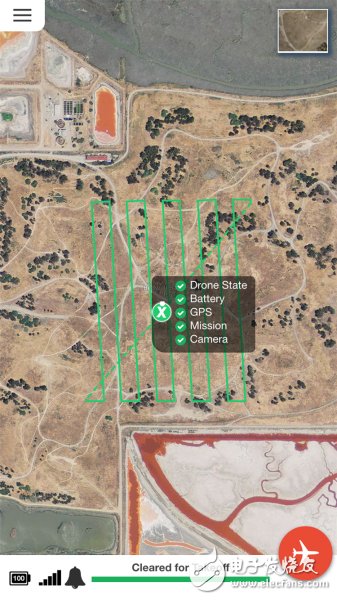
For drone enthusiasts, after launching the drone and letting it land at high altitude for a period of time, we may have to wait a few hours to download the pictures taken with a third-party application and then put them Stitch into a picture to form an aerial view.
However, now we don't need to be so troublesome. The startup DroneDeploy shows us a drone navigation and 3D model technology that automatically controls mass consumer and enterprise drones and manages the pictures taken by drones while still in drones. When we were flying overhead, a picture appeared on the phone and it was drawn into a map.

The DroneDeploy branded application from DroneDeploy supports both iOS and Android versions, which integrate with DJI drones. DroneDeploy co-founder and CEO Mike Winn claims that the company has developed the world's first "real-time mapping" technology that even Google and NASA can't match.
Dr. Iain Butler, a drone software developer, said in an interview with the media that he did not believe that he could bond the pictures taken by the drone into one in seven hours before he watched the DroneDeploy technical demonstration video. A complete map of the technology. However, he said that Wayne promised that the technology would take only 15 minutes to complete. Wayne gave the reason: in some cases, 90% of the data was transmitted back before the drone returned to the road.
The DroneDeploy software is now integrated with the Phone 2 Vision+ drone developed by DJI, as well as 3D RoboTIcs and AgEagle. The software is capable of controlling the flight device by itself, and the user only needs to click on the mobile application on the phone. "Our software is really cool to make DJI an entertaining toy," said Nick Pilkington, chief technology officer and co-founder of DroneDeploy.
Currently, the software for DJI only supports Android devices, but the company said that the iOS version will be released in the next two months.
After the user opens the DroneDeploy application, he can see the aerial picture of his location. The user clicks on the screen to select the location where the mapping is required. The application will do several security tests in the background. When everything is ready, the Start Flight button will appear on the screen. Click the button and the drone will take off and start mapping. The entire process no longer requires manual user action.
DroneDeploy said that software operation is the key, because in bad weather conditions, flying equipment is difficult to manipulate. However, this software connected to the drone can do everything well.
The price of this software is 99 US dollars per month (about 613 yuan), it can send the drone to the location where the mapping is needed, and automatically complete the mapping work. Users can choose whether they need high-resolution, close-range maps (such as on-site construction sites) or maps with wider, lower-resolution maps (such as fields).
Pilkington said the DroneDeploy application allows the drone to fly over any terrain because it supports GPS and can be associated with geographic data. This means that when the drone is flying at high altitude, the software knows that the device may encounter “unexpected†and then chooses to avoid it.
Now, DroneDeploy is preparing to work with more drone production partners, and the startup will use new financing to build its own development team. Wayne said the company hopes to further improve its software to enable it to "actively" monitor "problems" for customers (such as rail operators), such as monitoring tracks, identifying objects, and identifying obstacles. In case of any abnormality, the software will inform the railway operator.
2222Bossgoo(China)Tecgnology.
(Bossgoo(China)Tecgnology) , https://www.tlqcjs.com